3 ニセコ町の現状と課題3-8
3-8 地目別の土地利用現況
ニセコ町の地目別土地利用状況は、平成12年1月1日現在で、田7.01キロ平方メートル、畑23.50キロ平方メートル、宅地2.07キロ平方メートル、原野40.08キロ平方メートル、山林101.95キロ平方メートル、牧場0.92キロ平方メートル、雑種地3.59キロ平方メートル、池沼・その他18.01キロ平方メートルとなり、総面積が197.13キロ平方メートルとなっています。
総面積の半分以上が山林で、内約半分は道有林で占められており、国立・国定公園や各種保安林に指定されています。田畑等の耕作地は年々微減してきており、離農による耕作放棄地が目立ち、逆に宅地は微増が続いています。
総面積の半分以上が山林で、内約半分は道有林で占められており、国立・国定公園や各種保安林に指定されています。田畑等の耕作地は年々微減してきており、離農による耕作放棄地が目立ち、逆に宅地は微増が続いています。
グラフ17 地目別土地面積
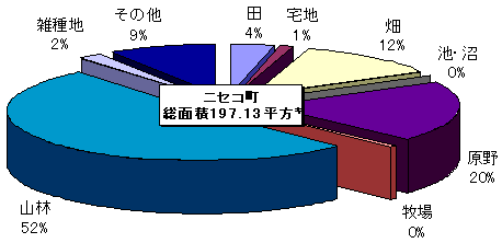
表4・5 町内の森林・公園面積
| 区分 | 面積(ヘクタール) |
| 人工林 | 2200 |
| (うち針葉樹) | 1947 |
| (うち広葉樹) | 253 |
| 天然林 | 10397 |
| (うち針葉樹) | 320 |
| (うち広葉樹) | 10077 |
| 樹林地総数 | 12597 |
| 伐採跡地 | 263 |
| 未立木地 | 372 |
| 公園 | ニセコ町内に占める面積 (ヘクタール) | 総面積 (ヘクタール) |
| 支笏洞爺国立公園 | 1374 | 99302 |
| ニセコ積丹小樽海岸国定公園 | 1280 | 19009 |
このページの情報に関するお問い合わせ先
- ニセコ町役場
- TEL:0136-44-2121
- FAX:0136-44-3500