Niseko Town Location and Access
Niseko Town Location
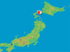
Niseko Town Location (Map of Japan)
Niseko Town is 140 degrees 48 minutes east longitude and 42 degrees 52 minutes north latitude. It is located in the western part of Hokkaido, almost in the center of Shimo-Kisu, and is surrounded by the mountains of Mt. Yotei National Park (1,898m) to the east and Niseko Annupuri (1,309m) to the north, forming a hill basin with many wavy slopes.
In the center of the town there is a Rishirigawa river (shining in Japan the most frequently in the past) and small and medium rivers such as the Konbu River, Nisekoanbetsu River, Makikawa River flow into it.
Niseko has an inland climate with an average temperature of 6.3°C. Snowfall during winter can reach up to 200cm in depth.
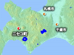
Niseko Town Location (Hokkaido Map)
Niseko town can be reached within 120 minutes from Sapporo City and Chitose airport, and 90 minutes from Otaru City by car.
Please see the following page for access to Niseko Town various means of transportation.
Please see the following page for access to Niseko Town various means of transportation.
Access to Niseko Town
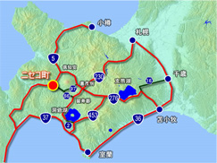
Access to Niseko Town
We will inform you about how to get to Niseko such as airplane, car, railway, bus etc.
Please see the following page for access to Niseko Town various means of transportation.
Please see the following page for access to Niseko Town various means of transportation.
Niseko Town Office (migration consultation counter)
Inquiries
- Planning & Environment Division
- TEL:0136-56-8837
- FAX:0136-44-3500