環境数値データ
1. 水の循環を支える緑のダム
1)水源を涵養する「緑のダム」機能を有する森林の状況
【グラフ1】天然林と人工林の面積の推移
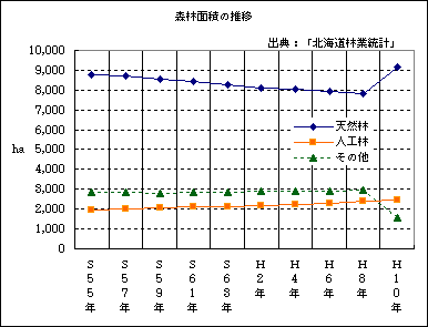
- グラフは語る
2.農業による水の循環機能への影響
1)下流の地下水涵養に貢献する中山間地域の水田面積
【グラフ2】水田と畑作の経営耕地面積の推移
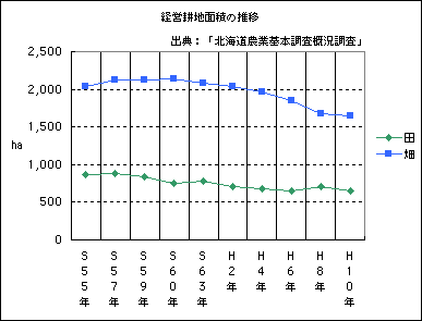
- グラフは語る
グラフによると、水田の経営耕地面積は減少傾向にあるものの、畑の減少率はそれを上回っています。このことから、地下水の涵養機能が低下していると思われます。
また、土壌診断によると、ニセコの畑土壌は、pHはやや低め、カリ成分の過剰、石灰分不足が特徴となっています。
2)畜産廃棄物の河川や地下水への流入
【グラフ3】家畜飼養頭羽数の推移
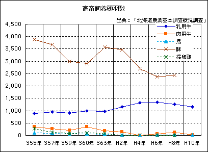
- グラフは語る
近年は1戸当たりの乳用牛頭数が急増したことから、これまで畜産堆肥舎の整備を積極的に進めてきました。14年度には、ほぼ全ての畜産農家の整備が完了します。また15年度には、畜産農家から排出される牛糞や厨芥ごみ(生ゴミ)、下水道活泥を合わせて堆肥化する「堆肥センター」を整備する計画です。
このページの情報に関するお問い合わせ先
- 企画環境課環境モデル都市推進係
- TEL:0136-56-8837
- FAX:0136-44-3500